Give me two days in that area with my metal detector, I'll find ya battle field.
I know where I'd be starting.
I know where I'd be starting.
What is the evidence to support the mainstream view that this is the site of the battle?@Enfield2band I'm going to try and explain the best I can why no artifacts and any kind of evidence has ever been found on the official battlefield and they never will find anything.
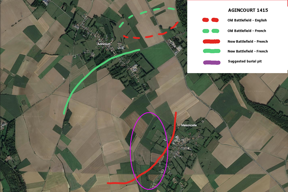
Here it is, 1500 yards wide at the top and 1000 yards wide funnelling down to 800 yards.
View attachment 462793
The key is the centre. The centre is at least 400 yards from the flanks at any given point. If Henry places his archers on the flanks which is written in all accounts BTW how is he going to defend the centre with only 1500 men at arms? Think about it. The maximum range of the longbow is 280-300 yards. If the French march down the centre of the battlefield, down the road then they are out of longbow range. Henry would never fight here in a month of Sundays, its too wide for archery support.
All the accounts say the archers were on the flanks and were hitting the centre where most of the damage was done.
Ain't no way no archer hits the centre of this battlefield and that's why they can't find arrow heads.
 www.medieval.eu
There isn't any, the battlefield survey failed to find one single artifact.This is a great thread
What is the evidence to support the mainstream view that this is the site of the battle?

Yes its took a few hits but a lot of the ground disturbances are square. The small bomb craters wouldn't account for the trauma in the field unless the launch site was in that field but it does put a new twist to it.Having a rummage around online for WW2 activity in the area and I've turned up something that will explain a lot of the soil disturbances right on your site unfortunately ...
Maisoncelle was the location of a V1 launch site and was obviously visited by the RAF at some point judging by the proliferation of bomb craters in the aerial photo.
V1-FSt 639
Übersicht der V1-Feuerstellung 639, Maisoncelle; Département Pas-de-Calais, Frankreich.www.christianch.ch
V1-FSt 639
Übersicht der V1-Feuerstellung 639, Maisoncelle; Département Pas-de-Calais, Frankreich.www.christianch.ch
")
The V1 site is just north of Maisoncelle and not in my proposed battlefield but bombs could have hit. Judging by the craters they are not big bombs. It does however discount the French attacking the English from the east so my battle direction has to be wrong.Having a rummage around online for WW2 activity in the area and I've turned up something that will explain a lot of the soil disturbances right on your site unfortunately ...
Maisoncelle was the location of a V1 launch site and was obviously visited by the RAF at some point judging by the proliferation of bomb craters in the aerial photo.
V1-FSt 639
Übersicht der V1-Feuerstellung 639, Maisoncelle; Département Pas-de-Calais, Frankreich.www.christianch.ch
V1-FSt 639
Übersicht der V1-Feuerstellung 639, Maisoncelle; Département Pas-de-Calais, Frankreich.www.christianch.ch
And Crecy, Waterloo, Trafalgar, the Nile, Mers-el-Kabir.....The battle was in 1415, and the French still hold a grudge against the British for it...
Feeding cattle might not produce high nitrogen in the soil, it would if it wasn't eaten and left.I think the soil damage you've highlighted in this pic is most likely bomb damage.
View attachment 462950
The 2015 imagery on Google Earth shows up the V1 site really nicely, particularly the launch ramp
View attachment 462955
View attachment 462954
A few of the rings of nettles next to sheds make me think they've been feeding cattle out as well, especially.
Love looking at satellite images. This was nice to find on our neighbours farm (2020 drought), hill fort overlooking the river. The round earth ditches clearly show up
View attachment 462956
Well stop faffin' about on here , off you trot and get detecting ...That's why I'm in this field. Annomolies not seen anywhere else in the area and I'm on it like a rash especially when its near L'Anglais.
This is where I'd start my survey with my detector. There is no where else to start. The official field has been done and nothing so you start at the last known English position and where there is at least ground activity.
")
When they built Ferrybridge power station they destroyed an entire bronze age settlement and never said a word. Twenty years ago they found a chariot and burial site next door during the A1M construction.You'd think the bombing and construction would have turned up artifacts , but I guess they had other things on their minds at the time.
They banned detecting years ago in most of France, you need a permit.Well stop faffin' about on here , off you trot and get detecting ...
Feeding cattle might not produce high nitrogen in the soil, it would if it wasn't eaten and left.
Usually you'll find nettles in patches are caused if you spill amonium nitrate fertilizer, heaps of dung or pits.
It can be many things. Pits are just one example.
The real crux of the argument is when you find oblongs or squares which cannot be accounted for.
That's why I'm in this field. Annomolies not seen anywhere else in the area and I'm on it like a rash especially when its near L'Anglais.
This is where I'd start my survey with my detector. There is no where else to start. The official field has been done and nothing so you start at the last known English position and where there is at least ground activity.
 their beds or their plates. The amount of dung and disturbance around a ring feeder is amazing, and any weed seeds are concentrated in the bottom, then new bale on top so goes fousty and gets left. still get nettles now even with spraying there's so much seedbank left behind
Couldn't you put it in the bottom of a shopping bag so its not obvious?.....Just joking.They banned detecting years ago in most of France, you need a permit.
Depends how long the nitrogen lasts. They are very, very nitrogen hungry just like Barley, wheat and other grasses.Couldn't you put it in the bottom of a shopping bag so its not obvious?.....Just joking.
A small point, nettles will grow where the ground has been disturbed and rubbish has been dumped they don't need fertiliser.