nav2022
Member Extraordinaire
When the battle of Towton battlefield was surveyed, they found 1000's of artifacts from battle, coins, arrow heads, sword bits, spurs etc. They've also found lots of bodies.
In contrast, When the battlefield was surveyed in 2003 in Agincourt, not one single artifact was found, not even an arrowhead. No bodies.
This leads me to believe they don't know where the battlefield is so I did a bit of research. The locals have a tradition that the English were camped at a place called L'Anglais which in French means 'The English'. This location is south of Agincourt just west of a place called Maisoncelle.
See this 1825 French map.

So what I did was start sniffing around this region for disturbed ground. Right at the side of L'Anglais I found this on the 2017 google earth.

Those metal detectorists among you that use google earth will recognise the disturbed ground.

This is the only disturbed ground in the whole region. These are pits and they are darker because when you disturb ground you disturb the drainage and get a contrast on google earth when this happens. I found a Celtic burial site using this method.
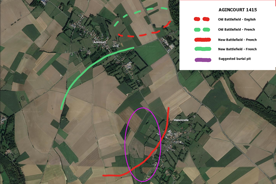
I think the battle was in this location and its 600 yard wide as described in the accounts, it funnels downhill just like the accounts and its boggy just like the accounts. I think the battlefield looked like this: French blue, English red.

Funelled the French into a quagmire and the archers on the flanks cut them to bits. I think the French came in from the road from Agincourt.
In contrast, When the battlefield was surveyed in 2003 in Agincourt, not one single artifact was found, not even an arrowhead. No bodies.
This leads me to believe they don't know where the battlefield is so I did a bit of research. The locals have a tradition that the English were camped at a place called L'Anglais which in French means 'The English'. This location is south of Agincourt just west of a place called Maisoncelle.
See this 1825 French map.
So what I did was start sniffing around this region for disturbed ground. Right at the side of L'Anglais I found this on the 2017 google earth.
Those metal detectorists among you that use google earth will recognise the disturbed ground.
This is the only disturbed ground in the whole region. These are pits and they are darker because when you disturb ground you disturb the drainage and get a contrast on google earth when this happens. I found a Celtic burial site using this method.
I think the battle was in this location and its 600 yard wide as described in the accounts, it funnels downhill just like the accounts and its boggy just like the accounts. I think the battlefield looked like this: French blue, English red.
Funelled the French into a quagmire and the archers on the flanks cut them to bits. I think the French came in from the road from Agincourt.
Last edited:


")

")